An ill-timed snowstorm that will unleash blizzard conditions moved into Minnesota on Wednesday morning, and its effects will be felt through the first part of the holiday weekend.
Snow started falling across southwestern Minnesota before sunrise and arrived in the Twin Cities by mid-morning, triggering snow emergencies and school closures — giving some students a jump-start on winter break. The Hopkins school district canceled classes Wednesday both because of the weather and because many bus drivers are out sick, the district wrote to families.
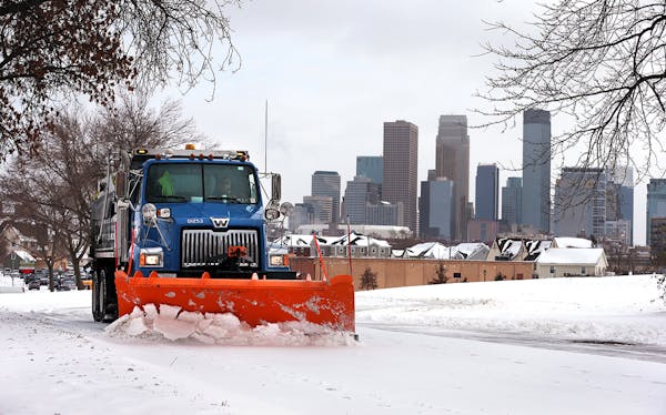
The storm dropped 5 to 9 inches of snow from Madison, Minn., in the western part of the state to Mankato to the Twin Cities to Eau Claire, Wis.
On Tuesday night, scores of shoppers descended on Cub Foods on 36th Avenue N. in Crystal in an attempt to beat the forecast.
"It was a madhouse," said assistant store director Mike Barrera, who said it was the busiest he had seen things since the onset of the pandemic. Customers were stocking up on baking supplies, milk, cheese, candy and last-minute gifts, he said.
Plows on Wednesday were doing their best to keep the parking lot clear of snow for customers such as Angela Scott, who waited until the afternoon to get her shopping done.
"I should have went yesterday," the Minneapolis resident said as she pushed a cart with her dog, Coco. Scott said she was coping with the bad weather, but she warned: "Stay off 494 — 25 miles an hour."
Road conditions continued to deteriorate throughout the day in the Twin Cities and across west-central Minnesota, where the heaviest snow totals were expected. Between 6 a.m. and 9:30 p.m., the State Patrol responded to 266 crashes, including 16 with injuries, 497 spinouts and a jackknifed semi.
"Expect difficult driving conditions through the rest of the week," the Minnesota Department of Public Safety said. "If you need to travel, slow down, wear your seat belt, put distractions away, increase your following distance and turn on your headlights."
The poor road conditions led to a school bus tipping over Wednesday afternoon in Camden Township in Carver County.
The Carver County Sheriff's Office responded just before 1:30 p.m. to the crash on 74th Street east of County Road 32, Sheriff Jason Kamerud said in a news release. Responding officers found that the driver and all 22 children on board escaped injury.
The snowy weather and conditions made it difficult for the driver to see the edge of the road, and the driver-side tires got caught on the south edge of the pavement, pulling it into a ditch, Kamerud said.
The bus tipped over on the driver's side, and a school bus service company responded to take the children home. Some were picked up by parents who came to the scene.
Northern Minnesota was also feeling the impact Wednesday. A winter storm warning remained in effect until Saturday for Duluth, the North Shore of Lake Superior and in an area from Brainerd to Hinckley and the western half of Wisconsin. More than 6 inches of snow was forecast in the area, the Weather Service said.
Slightly lower amounts of snow were predicted for places such as Rochester and Austin, according to the Weather Service. But the dangerous weather is expected to persist and bring whiteout conditions in some areas as winds pick up Thursday through Saturday morning.
A blizzard warning is covering a wide swath of Minnesota including Alexandria, St. Cloud, Willmar, Mankato, Rochester and Fairmont, with wind gusts as high as 50 mph expected and wind chill readings from minus 30 to minus 45 degrees.
"Travel plans for late this week should be adjusted now," the agency warned.
Officials at Minneapolis-St. Paul International Airport warned those flying to check with their carriers for delays and cancellations. By 6 p.m., 13 departing and 13 arriving flights at MSP had been canceled and 224 departing and 134 arriving flights were delayed, according to the flight tracking website flightaware.com. For about an hour Wednesday night, the FAA put the airport under a "ground stop" due to inclement weather.
Delta, United, Spirit, Sun Country and American airlines issued travel waivers, allowing customers to change their flights without charge.
At 5:30 p.m., Metro Transit said about 30% of buses were running behind schedule, with an average delay of about 6 minutes. No delays were reported on light-rail or commuter trains, the agency said. The westbound Route 61 is on a snow reroute.
Xcel Energy warned the snow plus high winds could lead to power outages, particularly in areas that have large, snow-covered trees near power lines.
Minneapolis, St. Paul, Osseo, Hastings, Plymouth, Hopkins, St. Louis Park, Crystal, Robbinsdale, Eden Prairie, Brooklyn Center and Brooklyn Park were among metro area cities to declare snow emergencies, and others were likely to follow.
The Minnesota History Center in St. Paul closed at 2 p.m. Wednesday and won't open Thursday. Other sites including Historic Fort Snelling, the Gale Family Library, Mill City Museum and the James J. Hill House will be shuttered Thursday, said spokeswoman Allison Ortiz.
The arctic blast was enough to keep Doug Tanner, 84, of northeast Minneapolis at home.
"I got a recliner. The refrigerator is full and the liquor locker is full," he said. "Life is good, but I feel for people who have to be out and about."
Here is a timeline of how things are expected to unfold:
Thursday
Northwest winds gusting as high as 50 mph will move in Thursday afternoon through Friday night, creating whiteout conditions across west-central and southern Minnesota.
A blizzard warning covering cities from Morris to Hutchinson to Mankato to Albert Lea will be in effect from Thursday through Friday. The Weather Service expanded the warning area to include Scott, Carver and Dakota counties in the metro area.
Wind chills will fall as low as minus 45 degrees, the National Weather Service said.
"Travel could be impossible and life-threatening," the Weather Service said.
Friday and Saturday
Conditions will remain extremely dangerous through midday Saturday, the Weather Service said. Blowing and drifting snow will make travel difficult. Low temperatures will be in the teens below zero, and wind gusts of 40 mph or stronger will create extremely dangerous wind chills beginning through Saturday, the National Weather Service said.
A thaw
The arctic air will hang around through Monday before temperatures begin to moderate to near 20 degrees above zero by Tuesday. The long-range forecast calls for warmer-than-normal conditions arriving by New Year's Eve and continuing into the first week of January, according to the Weather Service's long-range forecast.
Staff writer Josie Albertson-Grove contributed to this report.