Shovels, snow blowers and ice melt — Minnesotans will need them all over the next couple of days as the first significant storm of 2023 moves into the state and drops rain, freezing rain, sleet and snow.
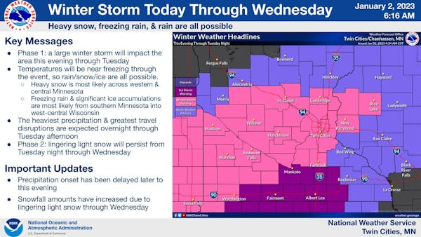
A winter storm warning went into effect Monday afternoon across western Minnesota and was expected to cover an area stretching from the southwestern part of the state to St. Cloud, the Twin Cities and western Wisconsin. The warning — in effect until Tuesday night — comes with the potential of 4 to 8 inches of snow in the metro area, while 6 to 10 inches could pile up across a swath of central and western Minnesota from Hutchinson to Redwood Falls to Marshall, the National Weather Service said.
The storm is not expected to be as windy or as cold as the blizzard two weeks ago, and those conditions should lead to heavier, wetter snow, according to Minnesota Department of Transportation spokeswoman Anne Meyer.
Plow crews were set to begin working around the clock in the Twin Cities starting at midnight Monday, she said.
"We'll continue on the road working 12-hour shifts 24 hours per day until we're back and we're clear, and this will probably last until Thursday or Friday," Meyer said.
Isolated pockets of a foot or more of snow are possible, with snow falling at 1 to 2 inches per hour at times Tuesday, the Weather Service said.
With temperatures on either side of freezing, rain, freezing rain and sleet is forecast to mix in with the snow and create slippery conditions.
An ice storm warning covering southern Minnesota went into effect at 6 p.m. Monday. Ice accumulation near a quarter-inch was expected in places such as Mankato, Albert Lea and Fairmont.
Many highways in southern Minnesota had icy conditions Monday night, with some having a half-mile of visibility or less, according to the state's highway conditions website MN 511. Those variable conditions will move into the Twin Cities on Tuesday.
Meyer suggested drivers check online to see what the road conditions are ahead of time, considering they will vary a lot throughout the next couple of days.
The worst conditions statewide will be Tuesday morning and early afternoon, with winds whipping between 20 and 35 mph and creating low visibility, the Weather Service said.
"Please adjust your travel plans for Tuesday if possible," the Weather Service warned. "Travel could be very difficult."
The weather could affect travel into Wednesday morning, when the storm will start to wind down.
Behind the storm, calmer conditions are expected from Thursday through the weekend with sunny skies Thursday, Friday and Sunday. There is a slight chance of snow on Saturday. Highs during the period will be in the teens and 20s, the Weather Service said.