Winter weather watches and warnings covered just about every Minnesota county on Tuesday as a potent storm moved across the state, bringing snow, rain, sleet, ice and strong winds that were expected to last through Saturday.
"Just about everybody in the state will be impacted in some way, shape or form over the next few days," said Brent Hewett, a meteorologist with the National Weather Service in Chanhassen.
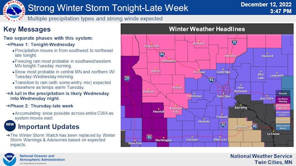
Dozens of schools across west-central Minnesota — where winter storm warnings for 3 to 6 inches of snow were in effect through early and midday Wednesday — delayed starts, closed early, or closed altogether Tuesday. In southwestern Minnesota, freezing rain combined with winds gusting up to 50 mph triggered an ice storm warning through noon, Hewett said.
More schools plan to be closed Wednesday, when some places could see as much as a half-inch of ice, Hewett said.
"That's a nasty type of precipitation," he said. "Don't travel if you don't need to."
In northeastern Minnesota, the wintry weather is expected to be more severe. Duluth and the North Shore are under a blizzard warning until 6 p.m. Thursday. That includes 16 to 30 inches of new snow accumulation and a "light glaze" of ice, according to the warning.
Other parts of northern Minnesota are forecast to get 6 to 7 inches of snow through 6 p.m. Wednesday as part of the winter storm warning.
The initial wave of precipitation moved into Minnesota on Tuesday morning but reached the Twin Cities only about lunchtime. Most was expected in the form of rain, with some freezing rain, sleet and snow possible. A winter weather advisory was in effect through early Wednesday for the metro and south-central Minnesota, with the possibility of 1 inch to 3 inches of accumulated snow, the Weather Service said.
The weather advisory also covered cities such as Albert Lea and Mankato and the Wisconsin cities of Eau Claire and Hayward, according to the Weather Service.
Heavy, wet snow was expected across the northern half of the state later Tuesday, with the greatest chance for 3 to 5 inches of snow from Alexandria to Mora and farther north, the Weather Service said. By late afternoon on Tuesday, there had yet to be any snowfall in the state.
"The expected amounts have dropped a little bit," meteorologist Tyler Hasenstein said.
Through Tuesday afternoon the closest area that received substantial snowfall was in southeast North Dakota, Hasenstein said.
Farther north near Duluth could see closer to 8 inches or more of snow overnight into Wednesday. The central and northern parts of Minnesota were expected to see a transition to snowy conditions Tuesday night into Wednesday, Hasenstein said.
"Duluth is looking like it's going to get hit pretty hard with snow overnight," Hasenstein said.
The amount of freezing rain also ended up being less than expected through early afternoon Tuesday, according to the NWS.
A massive low-pressure system over the central part of the United States will inch its way east, delivering a one-two punch. On Wednesday, the state will see a bit of a lull as the first system stalls out, but more precipitation will come Thursday and continue through the first part of the weekend.
Rain will wash away much of the snow covering the ground in southern Minnesota and the Twin Cities, but that was expected to be replaced with a new coating of 3 to 6 inches that will fall from Thursday through Saturday morning.
A system that triggers watches and warnings touching nearly all of Minnesota's 87 counties is a rare occurrence — something that usually happens once or twice a year.
"This is an impressive system," Hewett said. "It's going to be an active week."