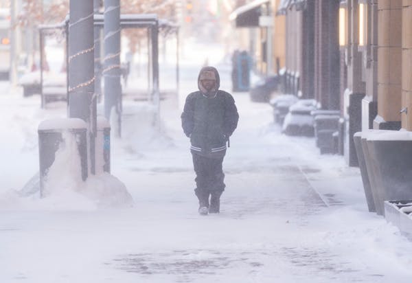
Minnesotans on Thursday braced for a monster winter storm already wreaking havoc in other parts of the country, just in time to threaten the last-minute deliveries and long-anticipated travel plans that accompany the Christmas holiday.
After a record-setting 8.1 inches of snow at Minneapolis-St. Paul International Airport on Wednesday, a Thursday morning respite ended as winds started picking up across western and southern Minnesota in the afternoon. The 20- to 25-mph gusts created extremely low visibility along Interstate 90 and in the Redwood Falls area. Conditions were so bad in Renville County, about two hours west of the Twin Cities, that the Public Works Department pulled its plows off the roads at noon.
Windchill readings at 2 p.m. included 44 below in Worthington and Slayton, the coldest in the state at that time. Right behind at 40 below or colder were Alexandria, Olivia and Glenwood in central Minnesota, said meteorologist Tyler Hasenstein with the National Weather Service in the Twin Cities.
"It's creeping closer" to the Twin Cities, Hasenstein said, although the truly brutal Arctic air wasn't expected to reach the metro until late Thursday. "That is when it will take a turn for the worse."
A blizzard warning went into effect Thursday afternoon in areas of Minnesota west of the Mississippi River, while a winter storm warning covered areas east of the river, with both in place through Friday night, the Weather Service said.
"Several hours of whiteout conditions are expected this afternoon onward, even in metropolitan areas," the Weather Service said. By early evening, the Minnesota Department of Transportation was advising no travel overnight in 13 southwest counties "due to limited visibility and extreme weather conditions which may be life-threatening if stranded." The agency also closed Interstate 90 west of Albert Lea to the South Dakota border as of 7 p.m.
Minneapolis, St. Paul and multiple metro-area suburbs declared snow emergencies that continued Thursday.
Snow totals included 8.1 inches in Robbinsdale and Ramsey, 8 inches in Lakeville, 7.5 inches in White Bear Lake, 7.3 inches in Savage and Shakopee, 6.9 inches in Fridley, 6.5 inches in Oakdale, 5.9 inches in Bloomington and 5.5 inches in Red Wing, the Weather Service said.
All that snow combined with frigid conditions allowed the precipitation to freeze and compact on the pavement, making for icy morning driving. The State Patrol reported responding to hundreds of crashes and spinouts statewide Thursday.
"Slick spots may abound," said MnDOT spokeswoman Anne Meyer. While the agency has 200 plows working in the Twin Cities and hundreds more across the state, "it takes longer" in the cold because chemicals don't work as fast or as well. "Crews are out there and we are doing what we can with what we have," she said.
City streets were not much better. Metro Transit said buses were running behind schedule on nearly half of all routes by Thursday afternoon.
In the Minnesota River Valley, 100 people and 50 horses were traveling to Mankato as part of the Dakota 38 + 2 memorial ride — and, for the time being, the cold wasn't too bad.
Besides, Todd Finney, who is the ride's ayapha or "voice," has seen worse. Some years, the riders have experienced windchills as cold as 70 below, he said.
The annual ride, which begins in Lower Brule, S.D.,honors the Dakota 38 + 2 — the 38 Dakota who were hanged on Dec. 26, 1862. The "2" symbolizes two men who were later captured and hanged. On Thursday, the group traveled 16 miles from Morton, Minn., to Fort Ridgely near Fairfax, Minn.
"Today, because we're down in the river valley, it was actually really nice because the storm was up above us," Finney said.
Thursday and Friday were expected to be busy travel days at Minneapolis-St. Paul International Airport, with 33,000 passengers expected to pass through security checkpoints each day. But Wednesday's snowstorm upended estimates, causing major airlines to issue waivers to travelers to rebook their flights without penalty.
"We had a lot more passengers move their flights to [Wednesday]," said MAC spokesman Jeff Lea, making for "a very difficult day."
By Thursday afternoon, some 80 flights out of MSP had been canceled and 66 delayed. Most of the canceled flights appeared to be those in the heart of the bomb cyclone, including Chicago, Denver and several Midwestern cities.
Siblings Will and Olivia McDowell were trying their hardest to get to Sioux Falls, S.D., after leaving Vienna (through Paris) the day before. Their flight had been canceled and they worried there might not be room on other flights to their hometown.
"I'm feeling a little homesick right about now," Will said. "We just want to get home and see our family."
Here's what to expect over the next three days:
Thursday night to Friday
Conditions will be the worst after 6 p.m. Thursday through most of Friday, the National Weather Service said. Peak winds will approach 40 mph between midnight and noon Friday. "Significant travel impacts are likely across the area," the Weather Service said.
Power outages are possible as snow caked on trees from last week's storm could cause branches to break and fall on power lines, the Weather Service said.
Saturday
Dangerously low windchills will envelop much of central and southern Minnesota through Saturday morning. The lowest readings are expected from 9 a.m. Thursday to 9 a.m. Friday and again Saturday morning.
Staff writers Zoë Jackson and Janet Moore contributed to this report.
United Arab Emirates struggles to recover after heaviest recorded rainfall ever hits desert nation
Here's why experts don't think cloud seeding played a role in Dubai's downpour
A cool and gusty spell, but more spring is ahead